The article expostulates the archaeological research of the above scholars who have explored the backbone of the Sassanian Spāh’s fortification systems for the defence of the northeastern marches of the Sassanian Empire: this was the densest concentration of mega-fortresses in the late antique world, in the Gorgan and Tehran Plains of Iran.
Readers further interested in Sassanian military architecture are referred to the following articles:
=======================================================================
In the 4th to 6th centuries CE, Persia was under attack from the north by the ‘White Huns’ and other powerful groups of steppe warriors. Persia’s response was to create a massive fortification belt – unsurpassed in scale anywhere in the ancient and medieval world, with only the possible exception of China.
Who built the ancient world’s largest fortresses? Many would probably point to the Roman army as the likely answer. Its legionary fortresses cover on average 15-25ha, while Britain’s largest Roman fortification – a temporary camp erected to protect a campaigning army – reached a size of 70ha. After the 3rd century CE, however, Rome ceased to erect well-entrenched camps, and late Roman legionary fortresses shrank to as little as 5ha in size. But even the largest Roman military compounds are dwarfed by Persian fortresses, which have a footprint of up to c.200ha – a size that is only reached elsewhere in the ancient world by cities or thinly occupied hilltop refuges. Yet not all of Persia’s giant geometric fortresses were cities. Instead, some sheltered vast armies living in tents. These fortifications contained no urban amenities or dwellings, and were accessible only via heavily guarded and narrow zigzag gateways. Why, then, were such exceptional fortifications constructed in late antique Persia?
From the 3rd century CE to the rise of Islam in the 7th century, Persia was ruled by the Sassanian dynasty. From the first decades of Sasanian rule, Persia proved capable of inflicting defeats on Rome, took major cities by storm and erected a siege camp at Hatra in Iraq, which is more than twice the size of any known Roman camp. Thanks to its military feats, the Persian Empire expanded to the Caucasus passes in the north and the River Indus in modern Pakistan in the east.
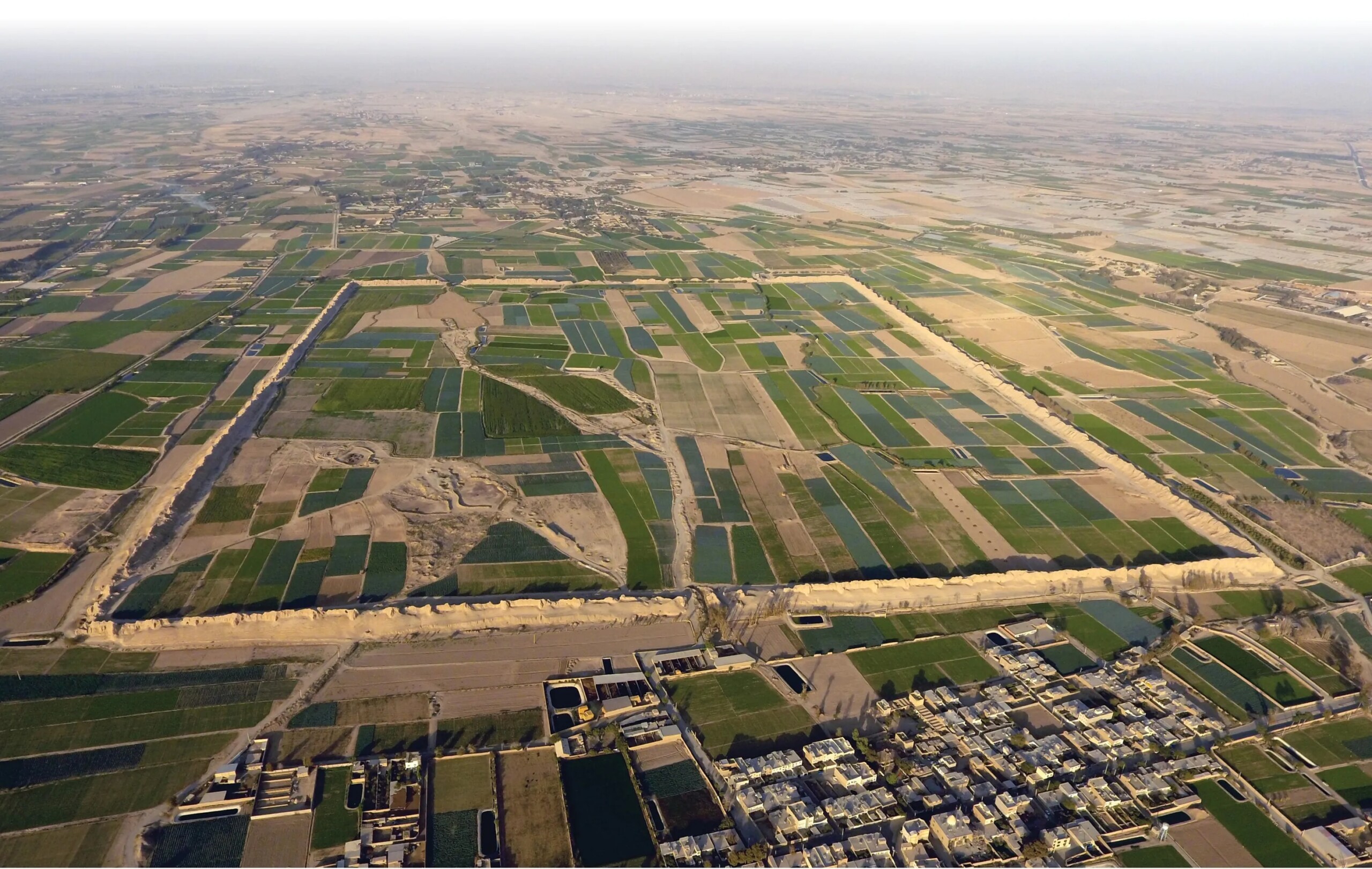
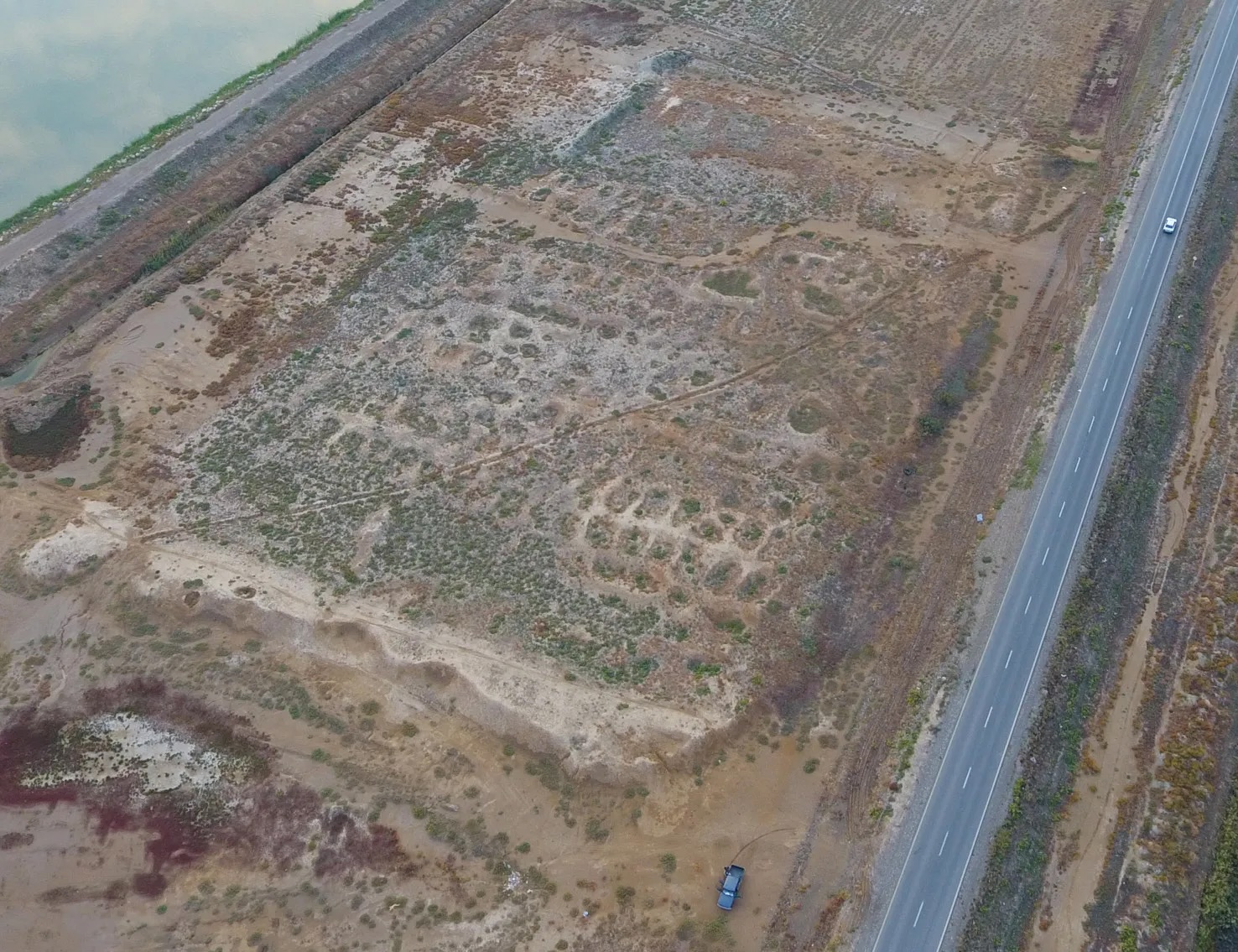
The Near East is the place to look for the ancient world’s largest fortresses. Here we see Qal‘eh Iraj, which – at 187ha in size – is one of the largest non-urban fortresses in the Sassanian Empire. This drone image was taken by Davit Naskidashvili as part of the joint project (Image Source: Joint Project published in World Archaeology).
It was in the 4th century that the Huns and related groups moved westwards from central Asia. Sasanian and Roman territories came under attack from these northern steppe warriors and other ethnic groups pushed out of their former domiciles. The onslaught caused Germanic tribes to migrate to Roman territory, forcing the Western Roman Empire to shrink in size and eventually cease to exist. How did Persia, closer to the epicentre of these large-scale population movements of the Migration Era, face up to the challenges that annihilated Western Europe’s dominant power? The answer included the construction of impressive fortifications, including both strongholds and great long walls, on its northern frontiers.
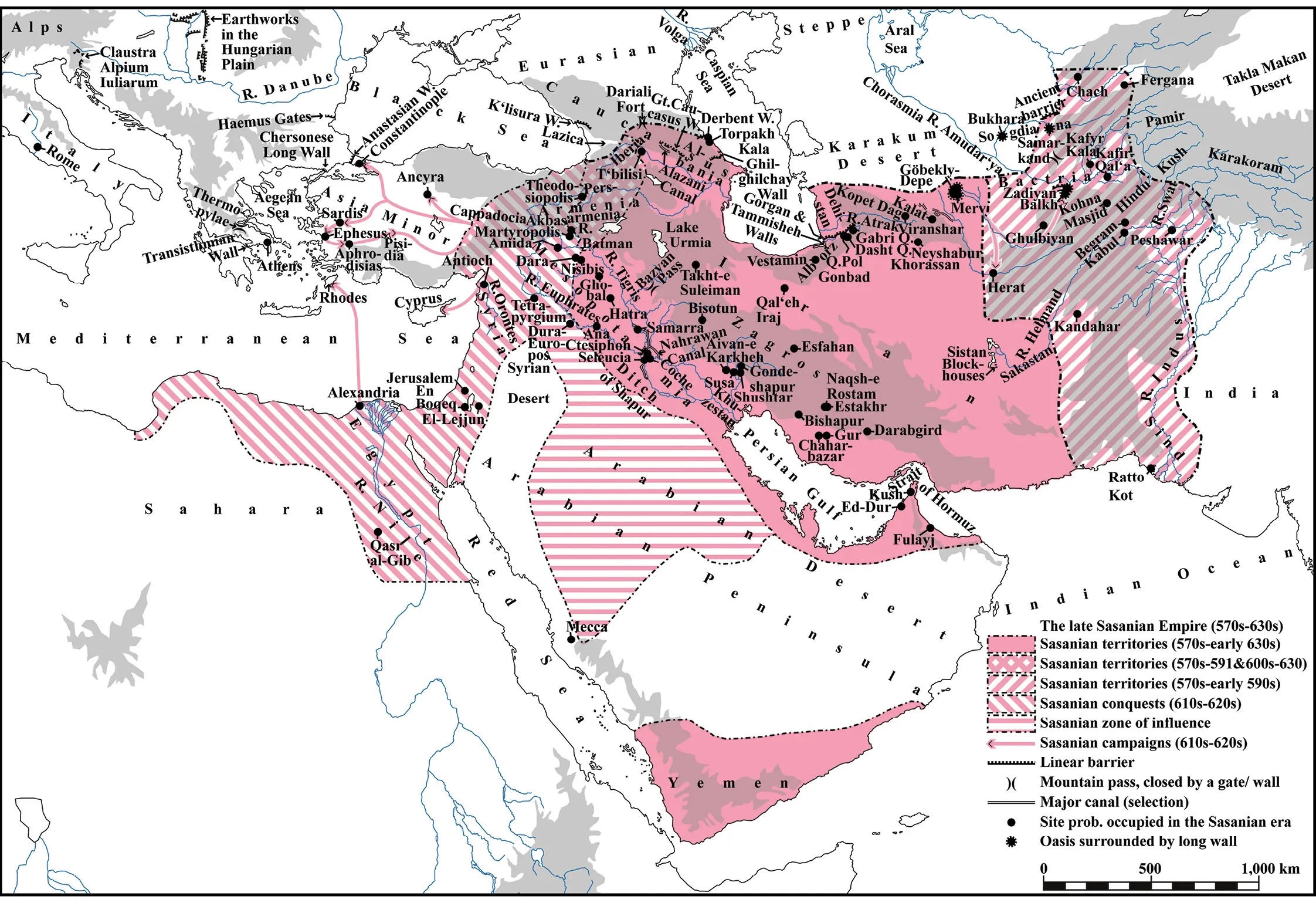
The Sassanian Empire was one of the ancient world’s largest empires (Image Source: Joint Project published in World Archaeology). In the late 6th century AD, it stretched to modern Pakistan and Uzbekistan in the east, to Yemen in the south, and to the Caucasus in the north. In the early 7th century, its armies conquered Syria and Egypt, and they advanced within striking distance of Europe’s richest and most populous city: Constantinople.
It was in 2005 that our joint team first explored the Great Wall of Gorgan and the Wall of Tammisheh in northern Iran, as well as some of the large fortresses in their hinterland (CWA 27). These walls are lined by more than 30 forts and thousands of brick kilns. We succeeded in dating their construction to the CE 420s-530s, most likely to the first half of this period. We have since excavated Sasanian fortifications built at the edge of rocky precipices in the Caucasus in Georgia to control traffic crossing Europe’s highest and most formidable mountain chain (CWA 80). The Sasanian Empire evidently invested heavily in its northern defences, and had the vision and skill to block the viable routes across its mountainous natural frontiers in the north. Yet it is our recent work in Iran that has thrown the sheer scale of Sassanian fortresses into sharp relief. Prior to 2016, the largest fortress scientifically dated to the Sasanian era covered a little over 40ha. It has now risen to 187ha, with a compound that is just one of several geometric fortifications extending over 1km2 in size. Richard Bates has also discovered previously unknown stretches of the Sasanian Walls submerged under the waters of the Caspian Sea. This is the world’s largest inland sea, and its rising and falling levels provide fascinating insights into climate change over the millennia. Our recent fieldwork has also provided us with a much better understanding of life in Sassanian forts.
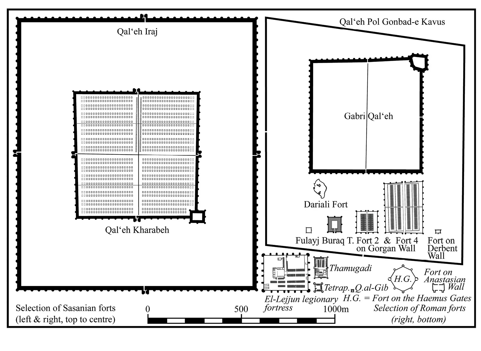
This size-comparison shows a selection of Sassanian and late Roman military compounds plotted to the same scale (Image Source: Joint Project published in World Archaeology). Qal‘eh Iraj is 40 times larger than the late Roman legionary fortress of El-Lejjun. Qal‘eh Iraj, Qal‘eh Pol Gonbad-e Kavus, and Gabri Qal‘eh are empty in the interior and were almost certainly, like Qal‘eh Kharabeh, giant military tent cities.
Life on Persia’s Frontiers
In 2006-2007, we dug two small trenches in one of the compounds, known as Fort 4, positioned along the Gorgan Wall. One of these excavations unearthed a small portion of two adjacent rooms within one of eight internal barracks, each some 116m long and at least an estimated 16m wide. In 2015-2016, we opened another trench across the entire width of a barrack block at a different site, Fort 2. To our surprise, we found that annexes had been added to the original barracks, almost tripling their width. When we last reported in CWA, we thought Sassanian barracks in forts on the Gorgan Wall were just two room-units wide. We now know that they were often six room-units (c.30m) wide and 80-120m long. The annexes were lightly built and probably single-storey, as opposed to the solid, double-storey original barracks. Even so, they doubled the floor-space available for accommodation and covered storage.
This drone photo by Davit Naskidashvili and the joint project shows Fort 4, the largest fort on the wall (Image Source: Joint Project published in World Archaeology). It had eight barracks, two each in a row, which are visible as oblong mounds (cut by post-Sasanian burial enclosures). The canal-lined Gorgan Wall is on the right.
Until recently, many scholars assumed that the Sasanian Empire lacked the manpower to permanently occupy the forts lining the Gorgan Wall and other linear barriers on its northern frontiers. An ability to garrison these fortifications is no longer in doubt: more than 40% of the interior of Fort 2 was covered with military-style housing. Survey suggests that other forts on the Gorgan Wall were as densely occupied as Fort 2. Much food and drink was permanently stored on the premises in large pits and storage jars, with a multitude of ovens and fireplaces available to cater for the hungry mouths that needed feeding. These probably ran to many hundreds in this fort alone, reaching tens of thousands along the entire Gorgan Wall. How could the state afford to maintain such a large garrison? Our excavations unearthed an assemblage of spindle whorls from the later phases of occupation, but we did not find a single coin. Marjan Mashkour’s examination of sheep and goat remains revealed that these mainly came from older animals whose meat was no longer tender. Perhaps military families occupied the forts. On the basis of the finds, they received no monetary stipends and only frugal provisions, produced some of their own cloth, and perhaps also some of their food. Maintaining such groups imposed no undue burden on the state. Indeed, firmly rooted in local society, they would have had every incentive to defend their homeland, plausibly making for a military force that was both affordable and effective.
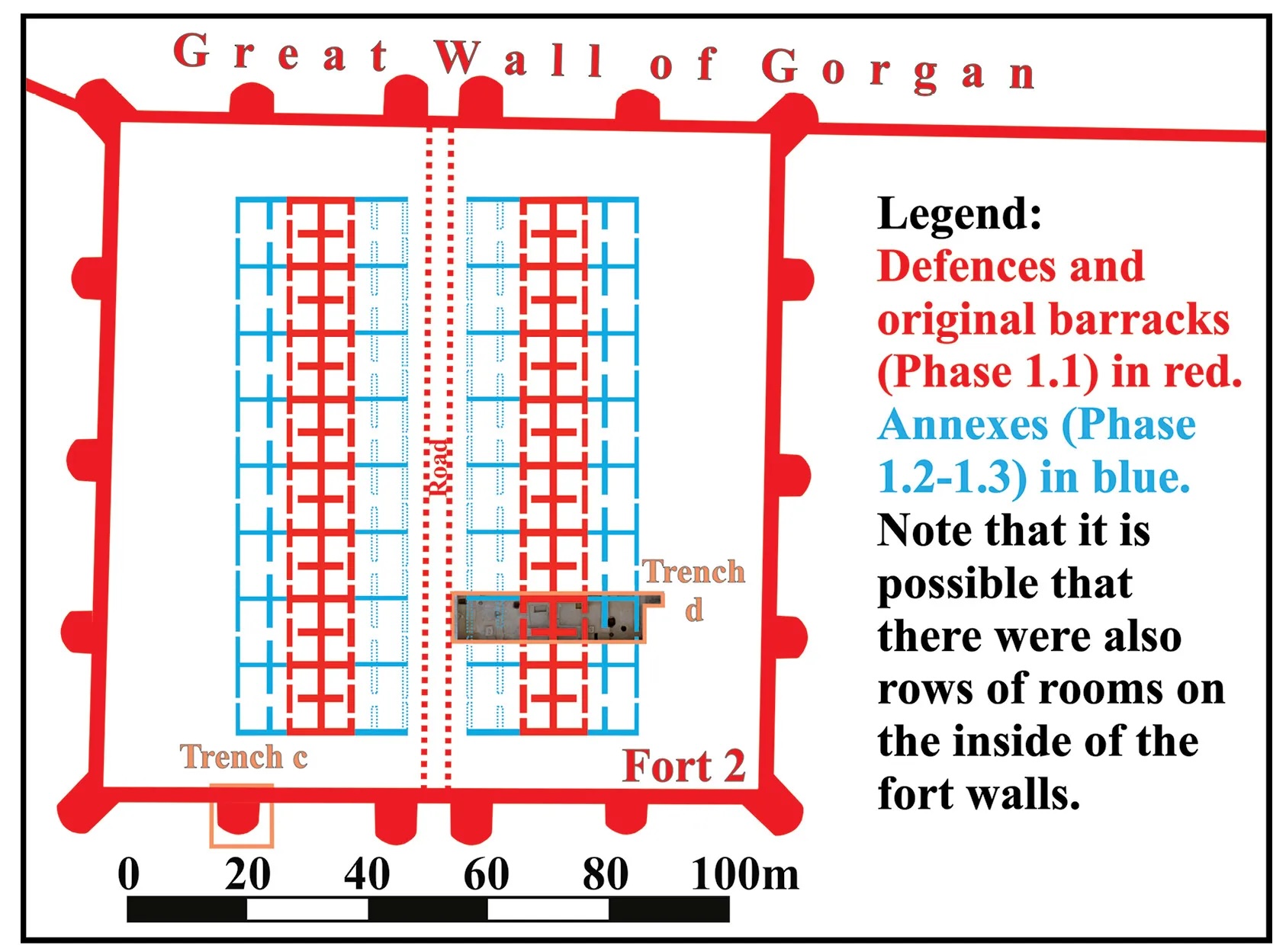
Fort 2, with two symmetrically arranged barracks in the interior, is 1.2ha large (Image Source: Joint Project published in World Archaeology). It represents the smallest and most common type of fort along the lowland section of the wall.
We also found one arrowhead, one bolt-head (perhaps crossbow ammunition), and a possible small dagger or combat knife. The Sassanian Empire’s northern adversaries were accomplished bowmen, making it unsurprising that the fort’s garrison had similar weaponry in their arsenal to keep their enemies at bay. While the quantity of military equipment left behind is small, this picture matches that of the contemporary late Roman forts in the Near East, which tend to yield a similarly low concentration. Metal was precious, and the garrisons of late Roman and Sasanian forts alike were evidently careful to recycle rather than to lose or discard such valuable material.
A River Frontier
In all, the Gorgan Wall stretched for more than 170km, making it one-and-a-half times the length of Hadrian’s Wall, but was the formidable Persian barrier the earliest line of control? It is not unusual for frontier walls to be later developments that grew out of earlier installation cordons. A chain of forts arranged along a highway known as the Stanegate preceded Hadrian’s Wall, for example. Likewise, the Roman frontier barriers in Germany replaced a succession of earlier fort chains, some along roads shadowing rivers, others lining overland routes. Perhaps unsurprisingly, there is now evidence to suggest that the Gorgan Wall – the late antique world’s longest fort-lined barrier – also succeeded a network of forts. Survey by our team, notably Kristen Hopper, led to the discovery of a variety of forts on the Gorgan Plain in recent years. At least four of them appear to be Sassanian in origin and are on or close to the Gorgan River.
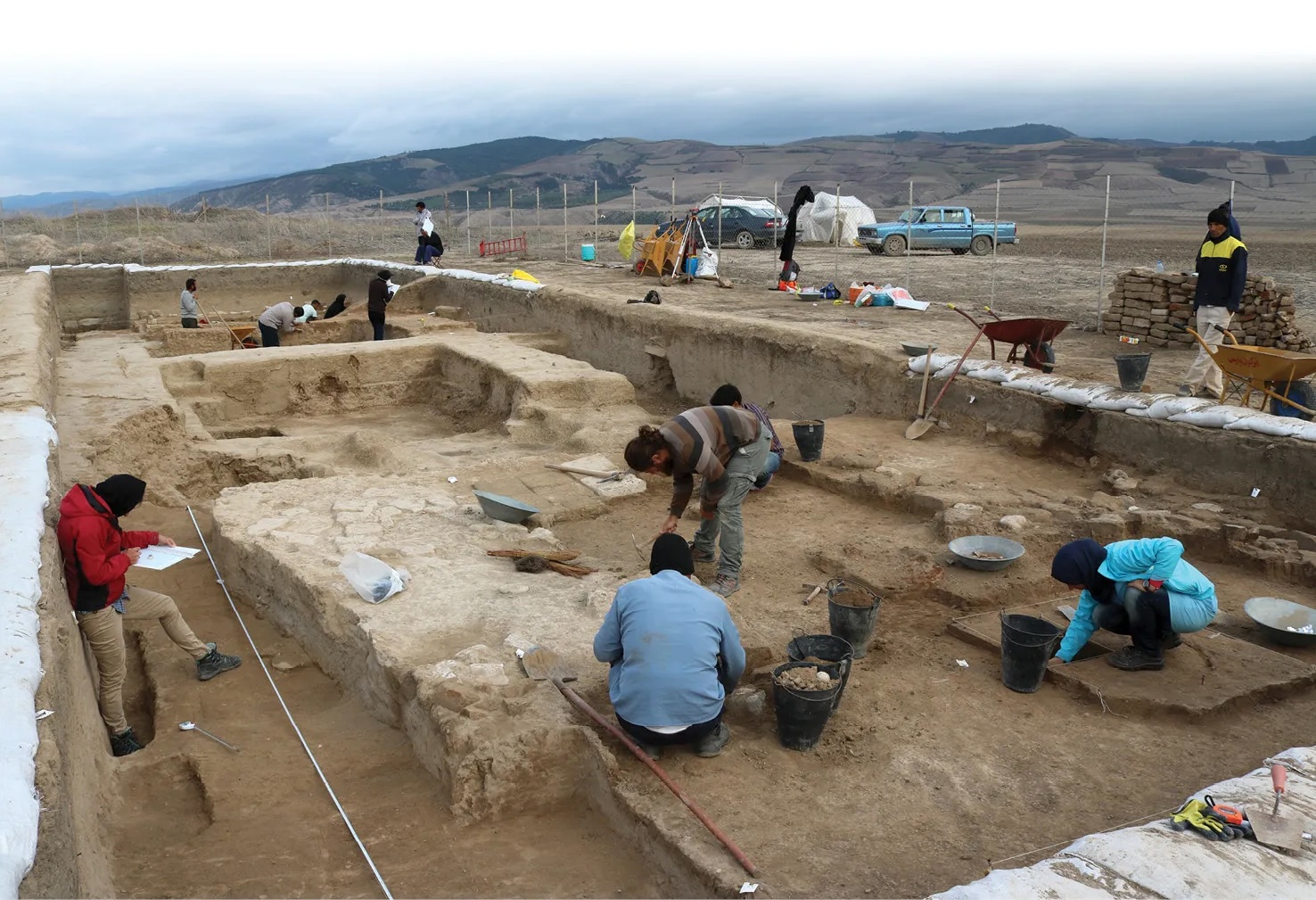
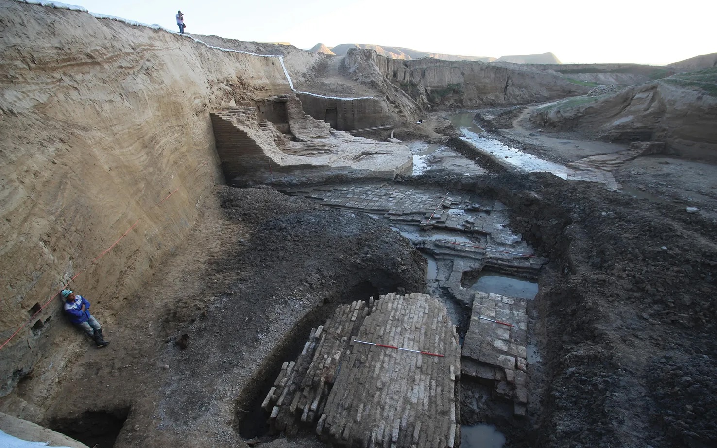
Excavations under way in Fort 2 (Image Source: Joint Project published in World Archaeology). Our excavations in Fort 2 revealed several distinct phases of occupation from the 5th to the late 6th or 7th centuries.
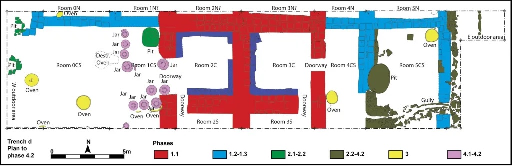
This plan shows features of the (mid?-) 6th century CE, with eight or nine separate ovens operational then in the area of our trench (not counting earlier and later fireplaces); two of the ovens were destroyed when one room was transformed into a storeroom (Image Source: Joint Project published in World Archaeology).
One of these forts, Buraq Tappeh (meaning ‘the White Mound’), was explored via geophysical survey and a sondage. This fort is smaller (c.0.5ha) than those on the Gorgan Wall. It was located some 4km south of the wall and once lay on a bank of the Gorgan River, which has subsequently changed its course. The fort’s architecture differs distinctly from that of its counterparts on the wall. Instead, Buraq Tappeh resembles a caravanserai, with accommodation lining the fort walls and a large courtyard at its heart. In both size and plan, it bears a striking resemblance to another Sasanian fort further upstream on the Gorgan River. Radiocarbon samples prove that Buraq Tappeh was occupied in the 5th to 6th centuries. Analysis of the pottery by Maria Daghmehchi suggests that while its occupation overlapped with that of the forts on the Gorgan Wall, activity at Buraq Tappeh started and ended earlier. The fort was probably part of a control line dating to the early 5th century. During later phases of occupation, Buraq Tappeh fell into disrepair, but was intermittently reoccupied. This can be explained by the stronghold now lying in the hinterland of the Gorgan Wall, making it surplus to requirements in normal circumstances, but offering a handy place of shelter during periods of crisis.
A drone photograph of Fort 26 (to the left of the road that follows the Gorgan Wall), by Davit Naskidashvili and the joint project (Image Source: Joint Project published in World Archaeology). Barracks filled much of the interior. Their decayed mud-brick walls are visible as yellow ridges, while subsidence of occupation deposits within has created small depressions in which water gathers and plants grow.
The Ancient World’s Largest Fortresses
While small forts like Buraq Tappeh were heavily defended and capable of housing a garrison of a few hundred soldiers, such a force was not sufficient to counter the threat facing the Gorgan Plain in the 5th century. Surviving sources attest that the area came under repeated attack by the ‘White Huns’ and associated groups. Several Sasanian kings personally led the efforts to defend the Gorgan Plain, which preserves evidence for the presence of massive field armies. Why was this region of such strategic significance? One reason is that the plain benefits from abundant rainfall, making it rich and fertile. The other is that it provides access to the Alborz mountain passes, which lead into the heartlands of northern Persia.
How could such vulnerable borderlands be defended? On the Gorgan Plain and elsewhere in the Sasanian Empire, a new type of fortification emerged, which was designed to keep mobile military reinforcements secure: geometric campaign bases protected by tall towered walls and a wide water-filled moat, with interiors that are mostly empty. The Gorgan Plain alone boasts seven such fortresses with internal areas of more than 35ha, as well as many more that are smaller or of uncertain date.
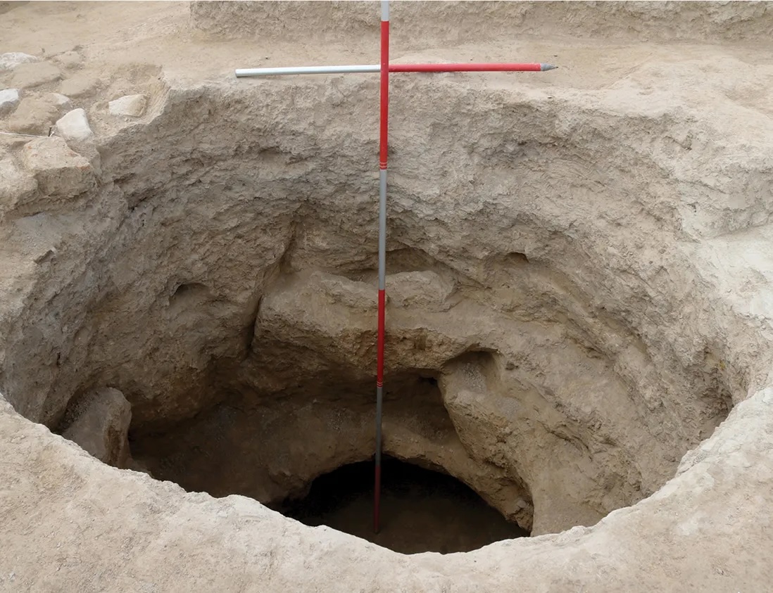
A 2.30m-deep bell-shaped storage pit, in which grain for the garrison would have been stored (Image Source: Joint Project published in World Archaeology). There were at least six storage pits in our trench, and perhaps up to 300 in Fort 2.
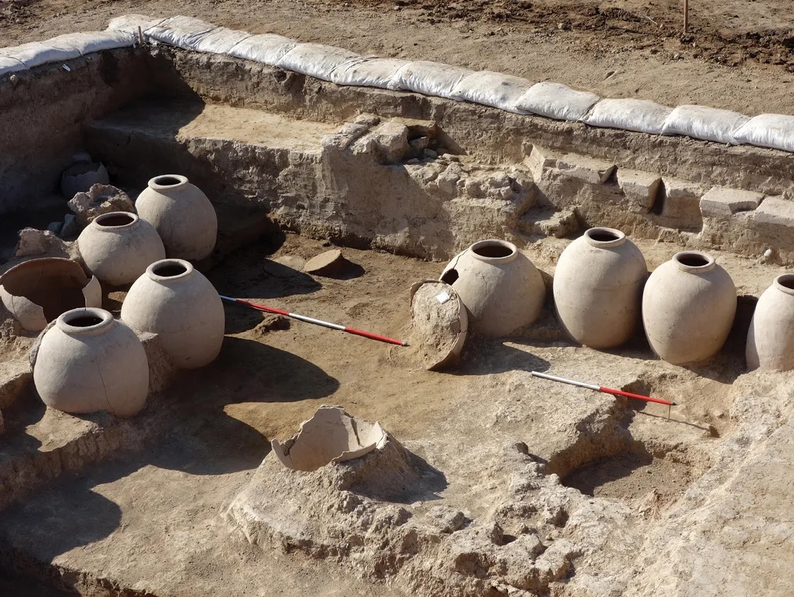
The large storage jars in a storeroom of the Fort 2 barracks (Image Source: Joint Project published in World Archaeology).
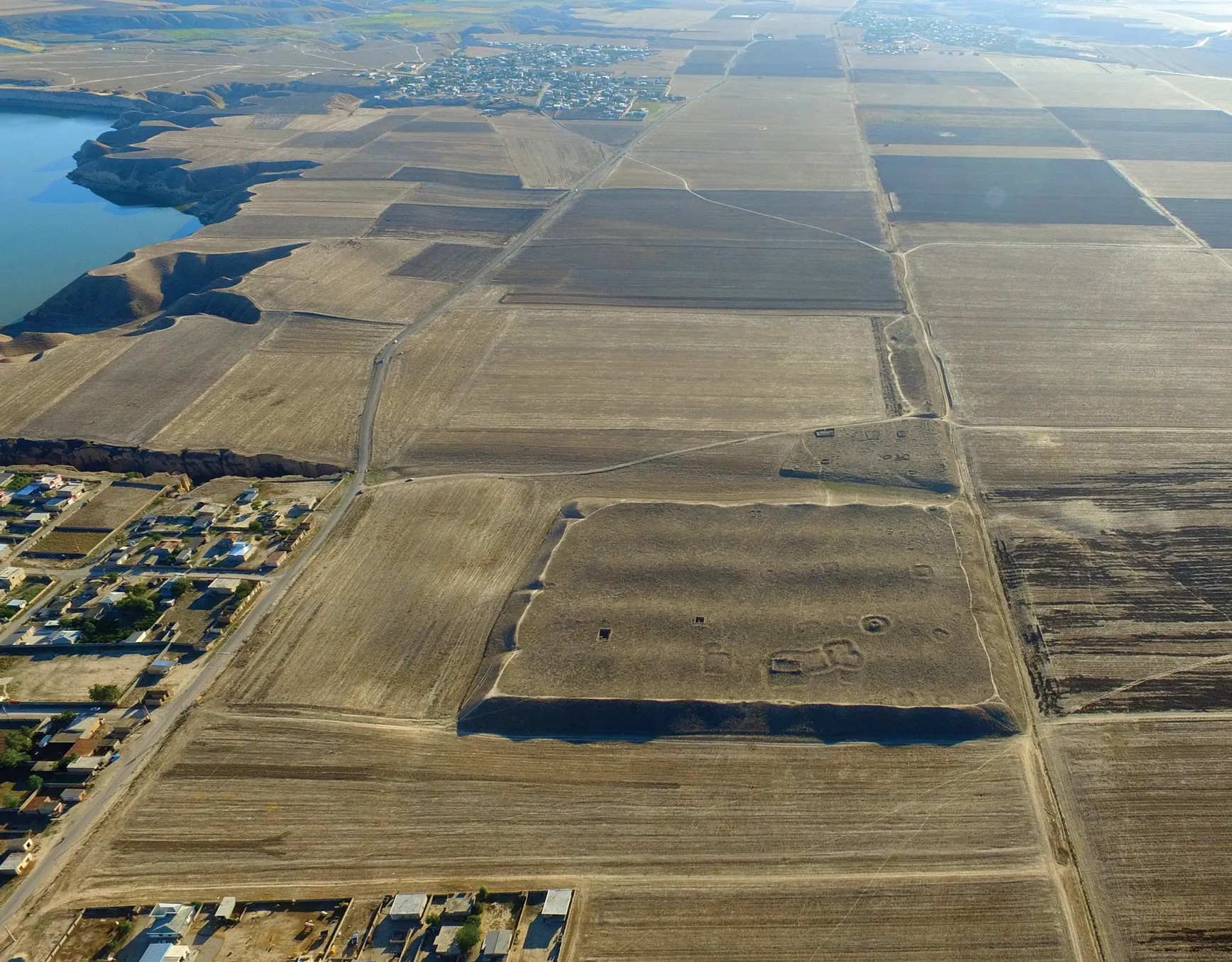
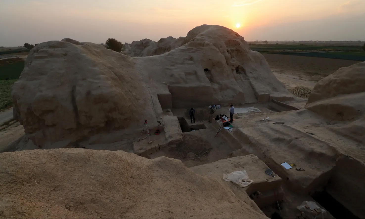
Perhaps the oldest fortress to be explored so far is a site with Sasanian and medieval pottery and the telling name Gabri Qal‘eh (‘the Zoroastrian Castle’). Two radiocarbon samples from the access causeway leading into the site indicate that it was built before the Gorgan Wall, with occupation reaching back to the 4th or early 5th century. Excavations within the interior have shown that it was ultimately transformed into a bustling medieval town occupied until the late 13th or 14th century. Perhaps it was the Black Death that brought about the final abandonment of this Sasanian foundation after a thousand years of occupation. But how can we know that it was a military fortress and not a town from the start? The relative abundance of Sasanian finds within the fabric of the access causeway proves that this element was not an original feature. Instead, it was only built after there was plenty of occupation debris around. Perhaps military-era deposits were then used as the building material for a causeway across the moat, at the same time that the fortress was being transformed into a town. Naturally, ease of access would be desirable for a town, while defensibility became a lower priority. This argument is admittedly speculative, but what is certain is that Gabri Qal‘eh is strikingly similar in plan and size to three other such compounds on the Gorgan Plain, and there is no evidence that any of the others was transformed into a town.
A drone photo of Fort 9, with the canal-lined Gorgan Wall visible on the right, by Davit Naskidashvili and the joint project (Image Source: Joint Project published in World Archaeology).
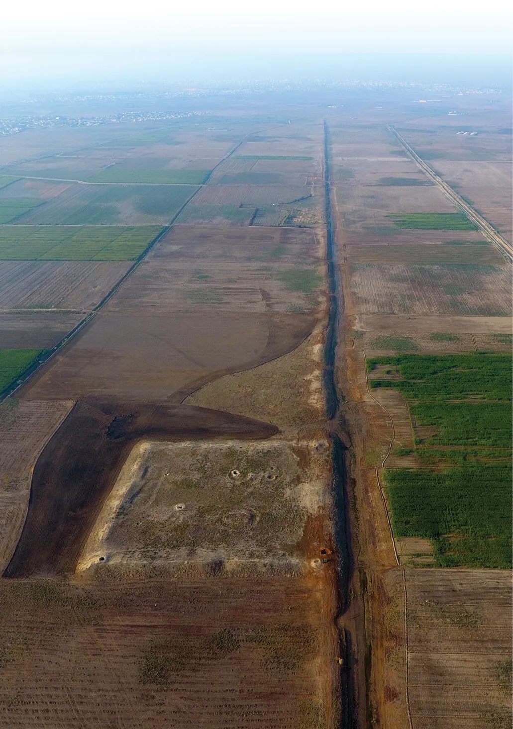
The best-known parallel for Gabri Qal‘eh is Qal‘eh Kharabeh (‘the Ruined Castle’), a site that is of crucial significance for establishing what purpose such compounds were designed to fulfil. Both magnetometer and aerial survey revealed that its interior was filled with neatly aligned double-rows of enclosures, each of them almost certainly dug around a tent. The wide access corridors in between each pair of double-rows provided plenty of space for tethering the soldiers’ horses. The tent enclosures evidently filled much or all of the eastern half of the vast interior (c.41ha), but oddly there is no trace of comparable features in the western half. Perhaps the enclosures date to a time when the compound was reoccupied by a unit that was half the size of the original garrison. If so, we can estimate that there were probably originally more than 1,000 tents in the interior – as well as probable additional housing in the fortress citadel and space in its 80 towers – which would mean the fortress could have comfortably sheltered at least 10,000 horsemen, and still have been less crowded than a Roman temporary camp. (A Roman camp of similar size would be suitable for a force of 20,000-30,000 foot soldiers.) Radiocarbon samples prove that Qal‘eh Kharabeh was occupied in the 5th or the first half of the 6th century, with the mid-5th century perhaps being the most likely construction date. This makes it possible that the garrison of this vast steppe compound oversaw construction of the Gorgan Wall, 2km to the north, but we cannot exclude the possibility that the fortress is a little earlier or a little later than the wall. Qal‘eh Kharabeh is so similar to Gabri Qal‘eh that it is hard not to believe that they were originally intended for the same purpose: both compounds are square with similar dimensions, both are neatly subdivided via central causeways, both boast a corner citadel, and both are defended by substantial tower-enforced walls and a massive moat.
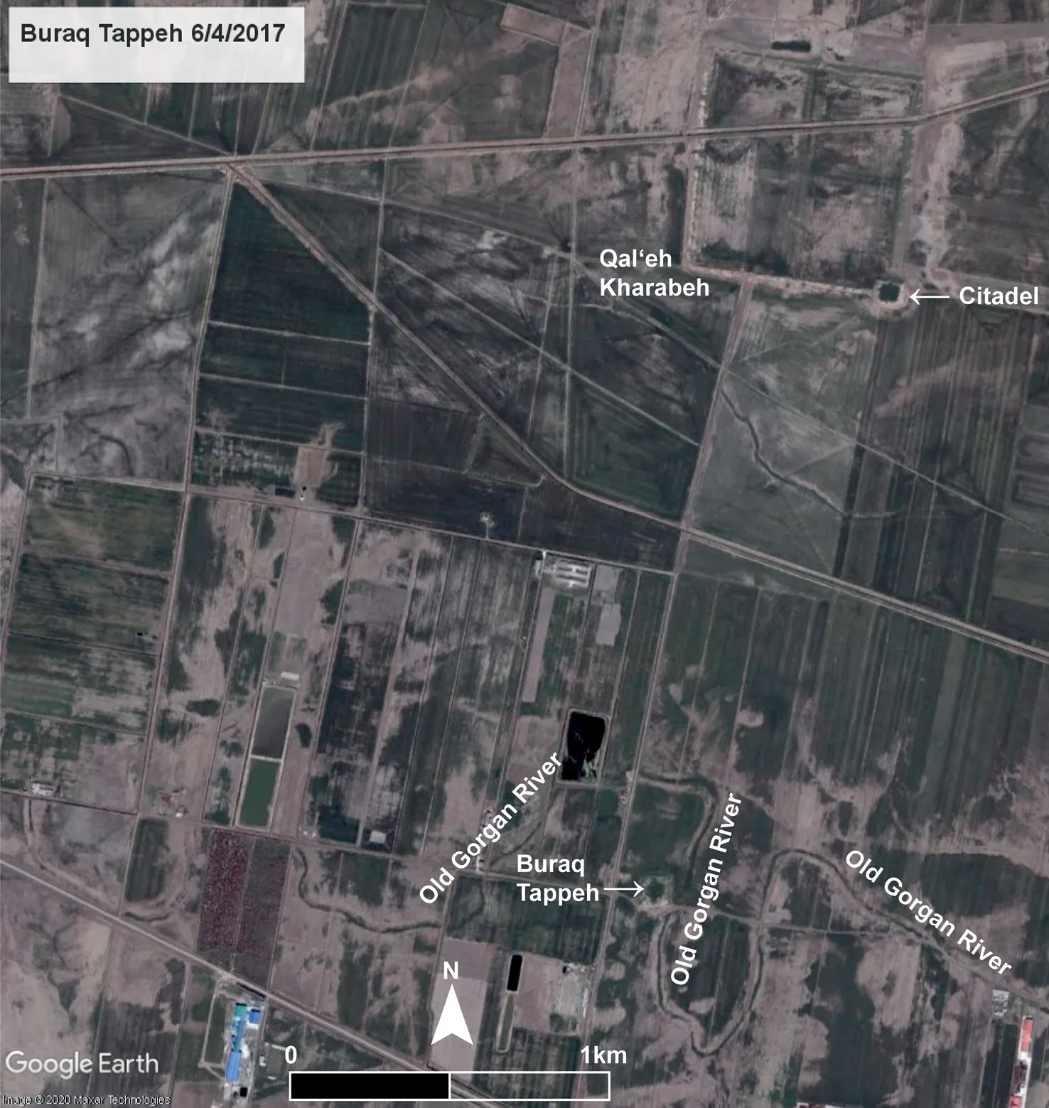
Buraq Tappeh: a courtyard fort on the Old Gorgan River, near the Qal‘eh Kharabeh Fortress (Image Source: Satellite Image by Maxar technologies published in World Archaeology).. It was probably part of a chain of forts that preceded the Gorgan Wall.
By far the largest such compound on the plain is Qal‘eh Pol Gonbad-e Kavus (‘the Castle at the Bridge to Gonbad-e Kavus’, the nearby city), which covers some 125ha. A radiocarbon sample from the site is compatible with construction at any point between the CE 430s and early 600s, but a date after 528 is most likely. The fortress could have comfortably sheltered 30,000 mounted soldiers. Was it perhaps here that King Khusro I had his headquarters while fighting a war against the Turks (then the dominant northern power) in the 560s? During that episode, it was reportedly the strength of the Sasanian defences on the Gorgan Plain that prevented the Turkish army from making inroads into Sasanian lands. Archaeology has supported this assessment, by demonstrating that great care was indeed taken to make the Gorgan Wall as impermeable as possible, with even minor stream crossings secured by massive bridge barriers.
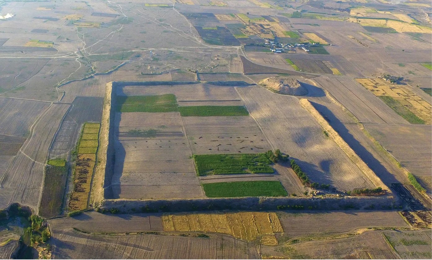
Gabri Qal‘eh, with its citadel and access causeway in the background, is the best-preserved and perhaps the earliest Sasanian fortress on the Gorgan Plain (Image Source: Joint Project published in World Archaeology). This drone image is by Davit Naskidashvili and the joint project (above).
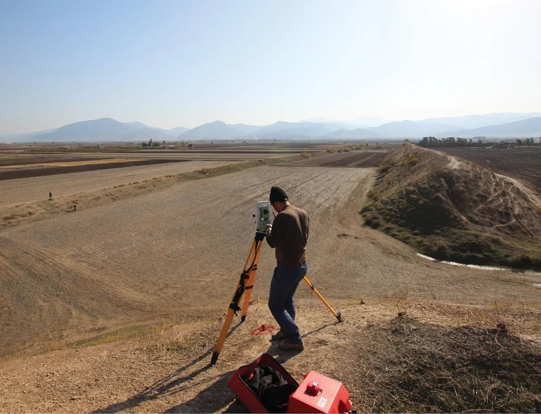
The ruins are also imposing at ground level, as this view from Gabri Qal‘eh’s citadel over its north-eastern wall and substantial moat demonstrates (Image Source: Joint Project published in World Archaeology). Team members, involved in survey at the outer edge of the moat, visually demonstrate its impressive dimensions.
Northern Defence Nerve Centre?
The Sassanian Empire not only fortified its northern frontiers more heavily than any previous empire had done, it also had reinforcements available in strong fortresses to the south of the wall. These strongholds include the giant fortress of Qal‘eh Iraj (‘the Castle of Iraj’, a legendary ancient Persian hero) c.290-440km south-west of the wall, which covered 187ha. Its wall circuit is 5.5km long, and it boasts 148 towers. An estimated 828 rooms were embedded in the ramparts to accommodate the soldiers patrolling these walls. If occupied as densely as postulated for Qal‘eh Kharabeh, there would have been space for 40,000-50,000 horsemen. Qal‘eh Iraj has been explored over many years by Mohammadreza Nemati and Mehdi Mousavinia, and we excavated two further trenches jointly. Our samples suggest that the fortress was built in the early 5th century. Ostraca deciphered by Carlo Cereti attest to supplies of a various foodstuffs, as well as horses, spades, and spears – fascinating evidence that a well-organised, literate administration was in charge of logistical matters, just as in the Roman army. This mega-fortress was probably occupied into the late Sasanian era, and may have functioned as both a command centre and major military base for the field army, with a capability of dispatching tens of thousands of men to any conflict zone within range. It could also have intercepted any hostile force that succeeded in crossing the Gorgan Wall or the Empire’s Caucasian frontiers, before they reached the heartlands of the Empire. In this way, one of the Empire’s strongest fortresses was strategically placed at the crossroads of northern Persia, a position that is occupied today by nearby Tehran, the modern capital of Iran.
The Gorgan Wall crossed this small stream via a massive bridge, which survives to a height of 7.50m (Image Source: Joint Project published in World Archaeology).
An Economic and Military Powerhouse
The Empire’s northern defences were not only impressive in scale, but seem to have been remarkably effective, too. So far as we are aware, no invasion reached the Empire’s breadbasket in Mesopotamia and south-western Persia between the late 4th and early 7th centuries. Surveys suggest that the population in many parts of the Empire rose to levels never seen before, while new cities, such as Dasht Qal‘eh (‘the Large Flat Castle’) on the Gorgan Plain, were established at a time when urbanism was in severe decline across much of Europe.
Excavations in the south-east gate of Qal‘eh Iraj have yielded written documents (Image Source: Joint Project published in World Archaeology). The gate is flanked by massive projecting towers, overlooking a narrow zigzag gateway.
Economic prosperity and the strength of the Empire’s defences enabled it to prevail against a powerful Romano-Turkish coalition that threatened it on two fronts. The Sasanians even succeeded in temporarily conquering Syria and Egypt in the early 7th century, pushing the Roman/Byzantine Empire to the brink of annihilation. Eventually, like all other ancient and medieval empires, the Sasanians fell, but they had prospered for far longer than most other empires of a similar size. Remarkably, when the fatal attack finally came, it was via the less well defended frontiers in the south. The heavily fortified north was the last part of the Sassanian Empire to fall to the Islamic Caliphate.
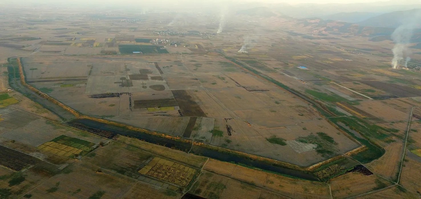
Urbanism in the Sasanian Empire flourished: the city of Dasht Qal‘eh on the Gorgan Plain was established in the 5th century and had 6.5km-long city walls (Image Source: Joint Project published in World Archaeology). This drone image is by Davit Naskidashvili and the joint project.
FURTHER INFORMATION
We are very grateful to our wonderful team, to the European Research Council for funding our fieldwork, and to our colleagues at the Iranian Centre for Archaeological Research and the Research Institute of Cultural Heritage and Tourism for their kind support.
To find out more, see our full report:
SOURCES
Eberhard Sauer, University of Edinburgh; Jebrael Nokandeh, National Museum of Iran and RICHT; Hamid Omrani Rekavandi, ICHHTO; Mohammadreza Nemati, ICAR; and Mehdi Mousavinia, University of Neyshabur.