Rouben Galichian was born in Tabriz, Iran, to a family of immigrant Armenians who had fled Van in 1915 to escape the Genocide, and who arrived in Iran via Armenia, Georgia and France. After attending school in Tehran, Rouben obtained a degree in Engineering from the University of Aston, Birmingham in 1963.

Rouben Galichian has written numerous books outlining the history and cartography of the Caucasus. He is also the author of a number of cartographic articles published in various magazines and has lectured extensively in Europe, the USA, Iran and Armenia. For his services to Armenian historical cartography, Rouben was awarded an Honorary Doctorate by the National Academy of Sciences of Armenia in November of 2008. In 2009 he was the recipient of “Vazgen I” cultural achievements medal. He is married and shares his time between London and Yerevan.
Rouben’s interest in geography and cartography started early in life and began seriously studying this subject sine the 1970s. In 1981 he moved to London with his family, where he had access to a huge variety of cartographic material. His books are described below

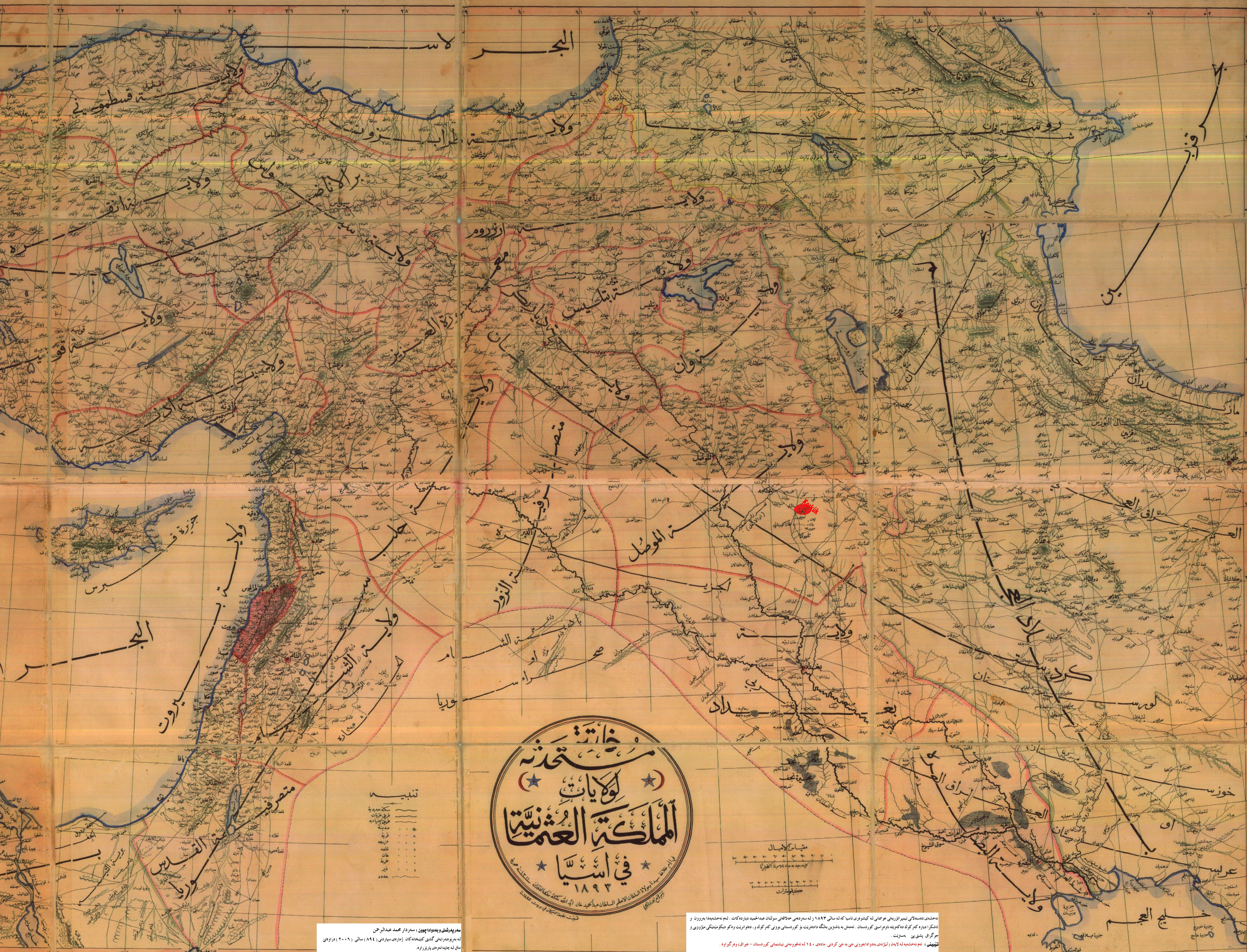
“Historic Maps of Armenia: The Cartographic Heritage (I. B Tauris, London, 2004) Note that expanded versions of the above book have been published (in Russian, Armenian [Printinfo Art Books, 2005], and English. The Russian translation of the book is available below in pdf: Мифологизация истории: Азербайджан, Армения,вымыслы и факты Galichian’s third book, is also laden with valuable historical information: “Countries South of the Caucasus in Medieval Maps: Armenia, Georgia and Azerbaijan” (Gomidas Institute, London, 2007) [see Amazon]. This text provides analytical historical-geographical information of this area for readers in the EU. For more information on this text click here… Galichian’s fourth and most recent book is: [CLICK TO ENLARGE]. Azerbaijan, Armenia and the Showcasing of Imagination (second, revised and expanded edition) (see Amazon). London/Yerevan 2010: Gomitas Institute & Printinfo Art Books. This book is also available in pdf – click here… The above book documents the native Armenian pedigree in Armenia and Nagorno-Karabagh through the centuries. The text is also of interest as it exposes the Republic of Azerbaijan or ROA [known as Arran until May 1918 – distinct from the historical Azerbaijan in Iran’s northwest] falsifications in historical and cultural fields. Galichian has completed another work dedicated to exposing the ROA’s falsifications of history, culture etc. The book draft is in Armenian but is to be transated into English. The work shall be entitled along the lines of “Historico-geographical Falsifications of Azerbaijan“. The book has alreayd been translated into Russian. In the work Galichian shall discuss the following: Galichian demonstrates that historical Azerbaijan has always been a province of ancient Iran (Media) and not the present-day Republic of Azerbaijan, which was thus named in May 1918. Kavehfarrokh.com will release more information on this upcoming text as soon as it goes to print. Nazrin Mehdiyova a historian from the Republic of Azarbaijan (ROA), has noted that “…for the purpose of breaking Azerbaijan’s historical links with Iran… Soviet authorities falsified documents and re-wrote history books…” (Mehdiyova, 2003, p.280). The policy of re-writing history books and falsifying documents has continued to the present day by the Baku authorities. Despite the historical facts, a number of historical revisionist views are officially taught as “history” at the elementary, secondary and post-secondary levels of the educational system in the Republic of Azarbaijan (Former Arran as opposed to historical Azarbaijan in Iran). It is also no secret that the teaching of history in the Republic of Azarbaijan is distorted with respect to its Iranian historical ties and legacy: سرنوشت غمبار تاریخ جمهوری آذربایجان اران در بیخبری ما + لینک دانلود فیلم Even children’s textbooks in Baku have became a major medium for the transmission of ethno-nationalist propaganda. For more on this topic consult a recent textbook entitled “Ata Yurdu” now being taught in Baku’s schools: –تبلیغات ضد ایرانی در کتابهای درسی رژیم حاکم بر باکو!-[Anti-Iranian propaganda in school textbooks printed by the current regime of Baku] The Ata Yurdu textbook is replete with historical falsifications such as the following: 1) The treaty of Golestan and Turkmenchai which Iran was forced to sign after her defeats by Russia) are re-narrated as having resulted in the “division of the independent kingdom of Azarbaijan by Iran and Russia”. This is false as (a) no independent Azarbaijan entity existed (b) historical Azarbaijan is in Iran below the Araxes River; the territories to the north were not known as “Azarbaijan” – these were known as Arran/Albania and the Khanates (c) the territories of the Caucasus ceded to Russia had historically elonged to Iran 2) Shah Ismail is narrated as the founder of the “Independent kingdom of azarbaijan” which is historically false. Ismail specifically re-asserted the sovereignty of the Iranian state and adopted the Persian title “Shah” instead of “Khan“. 3) The book also falsifies information on living persons. Shahyar, an iranian azarbaijani, is introduced as a “pan-Azarbaijani nationalist” when in fact the same Shahyar has written several verses praising Iran. History books are now being published for mass distribution at the international level. The textbook, “A Short History of Azerbaijan”, written by Yagub Mahmudlu and printed by the embassy of the Republic of Azarbaijan in Pakistan, is one such example. The book “A Short History of Azerbaijan” by Yagub Mahmudlu of Baku has essentially engaged in the rehabilitation of former Communist and pan-Turkist propaganda. The book contains a large number of historical distortions and falsified maps. The Mahmudlu book pretends that neither Iranian Azarbaijan nor Arran (modern Republic of Azarbaijan) were ever a part of Iran in history. The historical claims in the book are surprising due to their fantastically revisionist claims. Almost every single point in this book is either falsified or distorted. The notion of a “Greater Azarbaijan” is promoted at the official level by the Baku authorities (apolicy first promoted by the former Soviet Union). As noted by the aforementioned historian, Nazrin Mehdiyova the falsification of history has led to: “…the myth [of a North versus South Azarbaiajn ] became deeply ingrained in the population [of the Republic of Azarbaijan] and was adopted by the PFA [Popular Front of Azerbaijan] as part of the rhetoric.” Mehdiyova, 2003, p.280). Mahmudlu’s aforementioned book for example completely ignores the region’s long-standing associations with Iran and re-writes history to promote the “Greater Azarbaijan” myth – note one of the book’s maps below: A historically false map of an alleged “Greater Azarbaijan” during the Arab Caliphate. Historically all contemporary sources clearly distinguish between the real-historical Azarbaijan which is cited as being south of the Araxes River in northwest Iran versus Arran or Albania located to the north of the Araxes River. There are no maps or references that cite ancient Arran in the Caucasus aboves the Araxes River as “Azarbaijan”. As noted by the aforementioned Nazrin Mehdiyova: “…the myth [of a North versus South Azerbaijan] was invented under the Soviets for the purpose of breaking Azerbaijan’s historical links with Iran….(Mehdiyova, 2003, p.280). Shireen T. Hunter (see 1994, p.11) had earlier raised the alarm that the myth of a “divided Greater Azarbaijan” between Czarist Russia and Qajar Iran after the Golestan (1826) and Turkmenchai (1828) treaties had become a major mainstay of the newly independent Republic of Azarbaijan (following the collapse of the Soviet Union by the early 1990s). It is interesting that another western historian, Blum (2007, pp.106) clearly reports that modern-day Baku: “…boasts a well-established official national identity …there has been little historical basis for national identity formation among Azeri elites, who were significantly affected by Russification …”. There are even pan-Turk essayists from Baku who are forced to acknowledge these facts. One case is Nazim Dadasov who admits that “…If we look back to the history it will be very difficult to find the term “Azeri nation”. Historians have begun to use this term only during Soviet Union period”. You can corroborate this at: Dadasov, Nazim, “What is Azeri Nation”, March 26, 2008, posted on-line at International Research Club website (click here). Dadasov however is very biased. He explains the Soviet policy as having been in place to separate Arran-Albania from Turkey- he makes no mention that Arran was Iranian territory until relatively recently in the early 19th century. Once again, readers may be surprised to learn that a significant number of the modern-day inhabitants of Arran-Albania are unaware of their nation’s links with Iran. On this point, let us return to the modern-day educational policies of the Republic of Azarbaijan or Arran-Albania. Below is a Baku-government sponsored video animation (Azerbaijan Tarihi (Tarix)) showing a mythical “Greater” Azarbaijan being divided into a “Southern” and “Northern” Azarbaijan by Iran and Russia in the early 19th century (clock on picture to see the video): A post-Soviet era propaganda map produced in Baku. The above map (click on the above map to see the video) promotes the false notion that a “Greater Azerbaijan” was divided in two by Russia and Iran in 1828. Historically false claims such as these were first promoted by the pan-Turkists of the early 20th century which were then propagated by the former Soviet Union and the Communists, notably Joseph Stalin and Mirjaafar Baguirov. Unfortunately the legacy of historical amnesia has continued to persist at the official level in the Caucasian state. As noted by Professor Roy [Roy, O., The New Central Asia, I.B. Tauris, 2007] with respect to those territories situated above the Araxes abive the historical Azarbaijan province in Iran: ”The concept of Azeri identity barely appears at all before 1920. Up until that point Azerbaijan had been a purely geographical area. Before 1924, the Russians called Azeri Tatars “Turk” or “Muslims“[ Roy, 2007, p. 18] Note also Professor Kaufman [Kaufman, S., Modern Hatreds: The Symbolic Politics of Ethnic War, Cornell University Press, 2001] who has observed that: “In fact, the very name “Azerbaijani” was not widely used until the 1930s; before that Azerbaijani intellectuals were unsure whether they should call themselves Caucasian Turks, Muslims, Tatars, or something else” [Kaufman, 2001, p. 56]. Historical archives completely contradict what is essence post-Soviet (and pan-Turkist inspired) ethno-nationalist propaganda (and maps). Note a European map of 1805 below, just before the wars in which Russia conquered Iran’s Caucasian territories – note that there is no such entity as a “Azarbaijan kingdom” or “Greater Azarbaijan”. In fact all of modern day Republic of Azarbaijan were simply khanates which were part of the Iranian state. Map of Iran in 1805 before the invasions of Czarist Russia. Note the Caucasus, north of Iran and along the eastern Caspian littoral, which was Iranian territory. There was no “Greater Azarbaijan” supposedly “divided” between Iran and Russia. Russia invaded Iran and forced her to cede the Caucasus. Iran also lost important eastern territories such as Herat, which broke away with British support, Picture source from CAIS. The number of historical distortions on this subject has become so large that debunking these would require volumes of textbooks. On the other hand these falsifications are easy to dismiss with just a few sources. As we have already noted, no such “Southern” and “Northern” Azarbaijan entities are reported by native Caucasian sources, or European (i.e. Russian and British) sources. It is a sad fact that Elchibey went to his grave believing the historical fabrications of the Soviet Communist state, not to mention the falsifications made by the Tsars and pan-Turk activists. But what of the post-Elchibey era today? This is a more complex question as “officially” Baku and Tehran are on cordial terms. But one must look at the large picture as Baku is a close ally of Tel Aviv and Western lobbies – a vast topic which we need to discuss in a separate question. There are numerous references that can be produced to dismiss Mahmudlu’s Communist and pan-Turk inspired claims. Below is an actual map drafted during the Arab caliphates which reveal the historical Azarbaijan being in Iran and distinct from Arran (modern Republic of Azarbaijan), thereby revelaing the deliberate forgery seen in Mahmudlu’s map: A map drawn by Ibn Hawqal (ابن حوقل) during the Arab caliphates which shows the clear distinction between Arran (north east Caucasus just above Araxes), Armenia (north/northwest Caucasus just above Araxes River) and Azarbaijan inside Iran and below the Araxes River. Ibn-Hawqal:clearly cited the Araxes River as the southern limit of Arran. ابن حوقل نیز طبق نقشه ای که از سه سرزمین ارمنستان، آذربایجان و اران ارائه کرده است ، رود ارس را مرز میان آذربایجان و اران دانسته و هنگام بحث از شهرهای اران ، از بردعه ، جنزه ( گنجه ) شمکور ( شامخور ) ، تفلیس ، برزنج ، شماخیه ( شماخی ) ، شروان ، شاوران ، قبله و شکی ، نام برده ، اما شهرهای اردبیل ، دَه خرقان (دهخوارقان) ، تبریز ، سلماس ، خوی ، برکری ، ارمیه ( ارومیه ) ، مراغه ، اشنه ( آشنویه ) ، میانج ( میانه ) ، مرند و برزند را جزو شهرهای آذربایجان دانسته است . Here are more examples of the Arran-Azarbaijan distinction made by islamic and medieval era cartographers and historians: The Hodud-ol-Alam Text (10th century AD): Cites the Araxes River as the northern limit of Azerbaijan. Ibn Khordadbeh (ابن خردادبه): Clear distinction between Arran and Azarbaijan ابن خردادبه از اران و آذربایگان به طور جداگانه نام می برد و ضمن شرح شهرها و روستاهای آذربایجان ، نام شهرها و شهرکهایی را آورده که تماماً در جنوب رود ارس واقعند . اما از اران ، تفلیس ، بردعه ( بردع ) و بیلقان ( بیلگان ) ، قبله و شروان جداگانه نام برده و افزوده است که شهرستان های اران و جزو آن ( گرجستان ) و سیسجان جزو بلاد خزر بودند که نوشیروان به تصرف آورد . ابن فقیه مرز آذربایجان را از یک سو رود ارس و از سوی دیگر مرز زنجان و حدود دیلمستان و طرم ( طارم ) و گیلان دانسته است . و از شهرهای آذربایجان به این شرح نام می برد : « برکَری ، سلماس ، موقان ( مغان) ، خوی ، ورثان ( وردان ) ، مراغه ، نیریز » تبریز ، شاپور خواست ، برزه ، خونه ، میانه ، مرند ، خوی ، کولسره و برزند . . . » Al-Muqaddasi (10th Century AD): Divided Persia into eight regions which include both Azerbaijan and Arran. Defines Arran as being situated between the Caspian Sea and the Araxes River. Yaqut Al-Hamavi (13th Century AD) (یاقوت حمودی، ): Defines Arran and Azerbaijan as distinct territories with the Araxes River forming the boundary between them. Arran defined as north and west of the Araxes, with Azerbaijan to the south of the River یاقوت حمودی، در کتاب معروف «معجم البلدان» درباره این نواحی چنین مینویسد: Borhan-e-Qate (فرهنگ برهان قاطع) (Completed 1602 or 1632 AD – during the safavid era): Aras (Araxes) defined as a river flowing past Tbilisi in Georgia and forming the boundary between Arran and Azerbaijan. در فرهنگ برهان قاطع که محمد حسین بن خلف تبریزی آن را به سال 1602 هجری تألیف کرده است ، در شرح واژه ارس ، چنین می خوانیم : Hamdollah Mostofi (حمداله مستوفی): makes a clear distinction between Arran and azarbaijan being divided by the Araxes River. حمداله مستوفی نیز در کتاب مشهور نزهه القلوب ، از شهرهای آذربایجان یک به یک نام برده و میان دو رود ارس و کُرا اران و آن سوی رود کُر را شیروان می نامد .Abu al-Fadai Dameshqi (ابوالفدائ دمشقی): makes a clear distinction between Arran and azarbaijan being divided by the Araxes River. ابوالفدائ دمشقی که چهل و شش سال بعد از درگذشت یاقوت به دنیا آمده و کتاب کم نظیر تقویم البلدان را در سال 721 به پایان آورده است به روشنی تمام می نویسد: « اران . . . اقلیمی است مشهور که هم مرز آذربایجان است » و بعد اضافه می کند : « ارمنستان و اران و آذربایجان سه سرزمین بزرگ اند جدا از هم که اهل فن آنها را در یک نقشه نشان می دهند.» The same distinction in antiquity and pre-Islamic times is seen between Azarbaijan (in Iran) below the Araxes River versus Arran (in the Caucasus above the Araxes River with Strabo (64/63 BC-23 AD) who noted that the people of Iranian Azerbaijan (known as Media Atropatene at the time of Strabo) as Iranians with Persian as their language (Strabo, Geographica, see p. 17-18). Another example is Arrian (92-c. 175 AD) who noted that the region north of the Araxes River is cited as “Albania” and south of the Araxes as “Media Atropatene”. Sassanian emperor, Shapur I (r. 241-270 AD), cited Albania and Media Atropatene as two separate provinces of the Persian Empire. Professor Mark Whittow’s map of Oxford University clearly shows the historically attested distinction between ancient Arran/Albania and the original Azarbaijan in Iran. Note how the Araxes River separates Arran from the historical Azerbaijan (in Iran). Suffice it to say that there has been no entity known as a “Greater Azarbaijan” either before or after the Islamic era. Ottoman Map showing Iran in the Middle Ages (note that the map specifically states “Iran” in perso-Arabic script). The map also confirms that much of the Caucasus was Iranian territory and that Azarbaijan province in Iran is distinct from those Caucasian khanates (north of the Araxes), re-named in 1918 as “Republic of Azerbaijan”. Note that the Caucasian khanates (notably those areas now known as “Republic of Azarbaijan”) were part of Iran’s domains. The map (like all historical maps) makes clear that the so-called “Greater Azarbaijan state” (first promoted by the Soviets and now by Baku and its Western supporters) has never existed in history. 


جهانگرد معروف دیگر ابوعبدالله بشار مقدسی ، ضمن جدا دانستن آذربایگان و ارآن ، درباره محدوده جغرافیایی و شهرهای اران چنین نوشته است :
« اران سرزمینی است جزیره مانند ، میانه دریای خزر و رود ارس ، نهرالمَلِک ( رود کُر ) از طول آن را قطع می کند . مرکز آن بردعه است و شهرهای آن عبارتند از تفلیس قلعه ، خنان ، شمکور ( شامخور ) ، جنزه ( گنجه ) ، بردیج ، شماخی ، شروان ، باکویه ( باکو ) ، شابران ، دربند ، قبله ، شکی ، ملازگرد
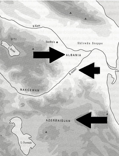
«اران نامی است ایرانی، دارای سرزمینی فراخ و شهرهای بسیار که یکی از آنها جنزه (گنجه) است و این همان است که مردم آن را گنجه گویند . میان آذربایجان و اران رودی است که آن را ارس گویند . آنچه در شمال و مغرب این رود نهاده است از اران و آنچه در سوی جنوب قرار گرفته است ، از آذربایجان است .
« ارس ـ به فتح اول و ثانی و سکون سین بی نقطه نام رودخانه ای است مشهور که از کنار تفلیس و مابین آذربایجان و ارّان می گذرد .